


Welcome to Change Makers, our series highlighting customer stories and builders making an incredible impact with Airtable. Today’s Change Maker was a runner up in the Airtable Community hackathon with his “show-stopping signature interface using complex polygons to map areas on a map” which we’ll dive into today!
As a Webflow developer, Walker Milhoan first heard about Airtable when he was looking for a data source to connect to Webflow. He quickly learned that Airtable works as a great backend and, since then, he’s developed nearly 20 websites that use Airtable entirely for management! Today, he’s helping the ranching community bring their operations into the modern century and empowering them to handle land management decisions with ease.
Meet Walker, Founder of Milhoan Design
⛷️ What's a fun fact most people (or your coworkers) don't know about you?
I'm a self-taught software developer with a pretty unconventional background – I've whitewater kayaked the Nile River, skied big Alaskan lines, and spent time working on cattle ranches in Africa.
🎧 Imagine the soundtrack of your life — what's your #1 song?
A: Wow, I can't pinpoint a single song because I love so many from so many from different genres. Some days I can't get enough Chris Ledoux, other days it's Tupac, or Metallica, or Bob Dylan, and some days it's Cat Stevens or Eric Clapton. It could even be Odesza.
💻 What's the first thing you ever built with Airtable?
Nick Pardo of Coefficient helped me build an event management platform for YETI Coolers. The app helps the company plan, organize, and run over 150 events globally with a budget of over $6MM.
🗯️ What advice would you give to someone just getting started with Airtable?
I would tell anyone who's just getting started in Airtable to just start building – that's the most effective way to learn this platform. Try to build bases around things that relate to your everyday life and don't worry about messing things up.
The Challenge & Airtable Solution
For over a year, Walker Milhoan (
"I have been self-promoting Airtable and it's benefits to the ranching community for over a year now. Maps are very important to ranchers, especially ones who operate on ranches that cover tens, thousands, hundred-thousand, and sometimes millions of acres," Walker explains. "It's very helpful to see the lay of the land from a 50,000 foot view."
Using Airtable Omni, Walker created a sophisticated mapping interface in just five minutes. The solution uses a Mapbox satellite base layer overlaid with polygon objects extracted from KML shape files. These polygons represent pastures and fields on ranching operations and contain critical data like rainfall measurements, grazing usage and duration, and other vital information that helps ranchers make more informed land management decisions.
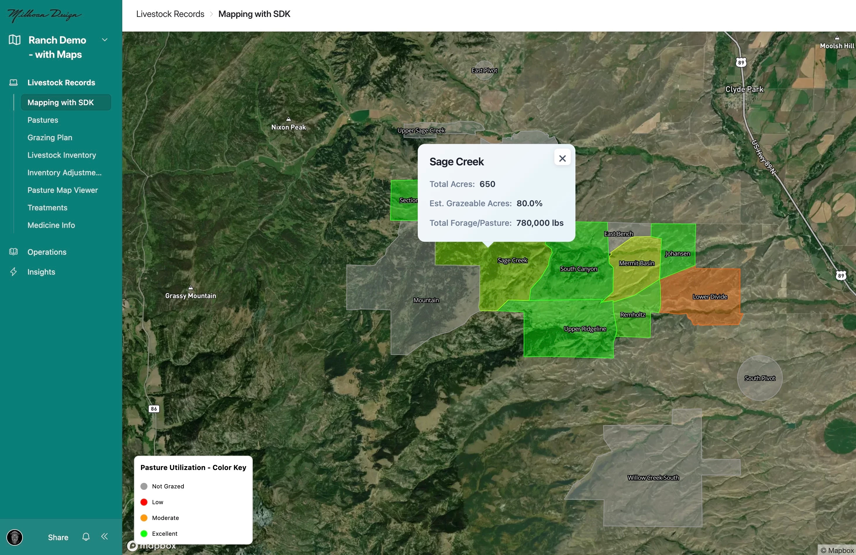
"I literally asked Omni, 'Please create a mapping layer that accepts a Mapbox token, and then pulls data in from my 'Pastures' table. Please use the objects in GeoJSON field to create the polygons on the map. Use a light green, slightly transparent color for the fill and stroke of the polygons.' And bam, it created exactly what I asked."
📺 Want to see it in action? Walker shared a demo of his workflow for the hackathon here:
The Results
The mapping interface has transformed Walker's ability to serve the ranching community. By addressing the critical need for visual land management tools, he's been able to significantly speed up workflows and scale his business offerings. The solution has also allowed him to consolidate his tech stack, reducing the need for separate mapping tools and creating a more streamlined experience within Airtable.
"This project is still in its infancy," Walker notes, "but there is tremendous opportunity for Airtable to become the best and most performative software for land management."
What's Next
Walker is currently leveraging the Interface SDK and Claude Code to further enhance his mapping interfaces. His innovative approach involves designing components in Adobe Illustrator, then using Claude Code to build them directly in Airtable.
"I can design a component in Adobe Illustrator, give it to Claude Code and ask it to build it in Airtable. It does a remarkable job!" Walker shares.
Beyond mapping, Walker is exploring all AI features available in Airtable, using Omni for custom interfaces, agents to parse and extract information from documents and receipts, and AI web search to develop comprehensive data tables.
Copy & Paste AI Prompt
Walker prompted Omni with:
Please create a mapping layer that accepts a Mapbox token, and then pulls data in from my 'Pastures' table. Please use the objects in GeoJSON field to create the polygons on the map. Use a light green, slightly transparent color for the fill and stroke of the polygons.
Did this use case inspire you? Drop a comment below if you try Walker’s technique to build your own base, and share how you’re using Airtable to change the way you work for a chance to be our next Change Maker spotlight!


